Shiretoko Peninsula
知床半島
標津町 · JP
Where drift ice meets brown bears — UNESCO's lowest-latitude sea-ice wilderness
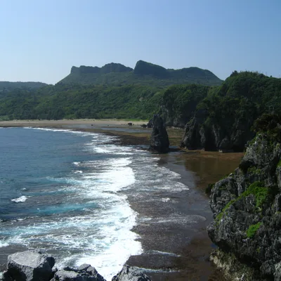
Jutting 70 km into the Sea of Okhotsk at Hokkaido's far east, the Shiretoko Peninsula hosts Earth's lowest-latitude regularly occurring sea ice. Ice-algae nutrients drive a food web from plankton to brown bears and fish owls — the rationale for UNESCO's 2005 inscription.
Best Season & Time
Peak drift-ice season: walk the floes from Utoro, or join a Rausu-side ice cruise to spot eagles on the ice
★★★★★
Shiretoko Goko's ground-level path opens, Mount Rausu climbing season starts and brown-bear sightings peak
★★★★★
Crimson foliage at Shiretoko Pass meets the salmon run; bears gather along streams for prime wildlife shots
★★★★☆
Alpine flowers bloom, sea ice melts away, and seabirds and migrating humpback whales return to the coast
★★★☆☆
Top 3 Highlights
1.Drift ice and the ice-algae-driven food chain
From late January through early March, sea ice from the Sea of Okhotsk piles against the peninsula's western coast. Ice algae beneath the floes seed a food chain that climbs from plankton to brown bears — the scientific keystone of the inscription.
Catch the ice fields aglow at sunrise from Utoro Port or Puyuni Cape; peak in mid-February
2.Shiretoko Goko: five lakes through primeval forest
A chain of five pools rimmed by primeval Mizunara oak and Todomatsu fir forest. The elevated boardwalk stays open year-round without reservations, while the ground-level path requires a certified guide during the bear-active season — wilderness rare in modern Japan.
From Ichiko's elevated deck, shoot Mount Rausu mirrored on glassy water during early-morning calm
3.Climbing Mount Rausu, the peninsula's apex
At 1,661 metres, Rausu-dake is the peninsula's highest peak. A round trip from the Iwaobetsu Onsen trailhead takes roughly ten hours; above tree line, dwarf-pine fields and alpine flora open onto sweeping views of Kunashiri Island and the Nemuro Strait on clear days.
Non-hikers can capture the long view from the Shiretoko Pass Observatory on National Route 334
Stories & Legends
Recommended For
Insider Tips
- 1.The Shiretoko Goko ground-level path requires a certified guide during the bear-active season (10 May to 31 July). Book through the official site well ahead — peak slots sell out a month in advance and walk-ups are turned away.
- 2.Drift-ice walks in Utoro use dry suits and dominate the marketing, but the Rausu-side ice cruise lets you watch Steller's and white-tailed eagles plus sea lions resting on floes — quietly favoured by wildlife photographers.
- 3.Cape Shiretoko is unreachable by road; the only access is a sightseeing cruise from Utoro. After the 2022 sinking many operators cut services, and cancellations are often decided at departure, so plan buffer days into your itinerary.
Visit Information
- Access
- From Memanbetsu Airport it is roughly a two-hour drive (about 100 km) to Utoro Onsen; from Kushiro Airport allow about three and a half hours. JR Shiretoko-Shari Station has bus connections, but services thin out in winter, so renting a car is strongly recommended.
- Time Required
- Minimum overnight stay; two to three nights recommended for full wildlife immersion
- Budget Guide
- Goko guided tour ~JPY 5,000, drift-ice walk JPY 6,000, sightseeing cruise JPY 9,000; budget JPY 50,000-70,000 for two nights with lodging, meals and car (2024; confirm officially)
Nearby Attractions
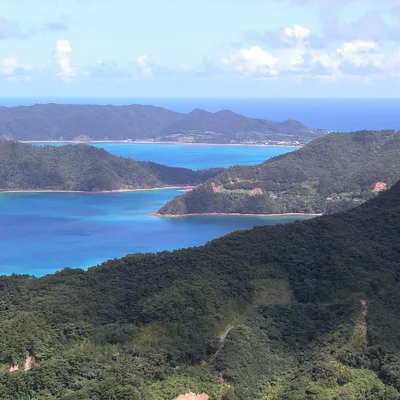
Roughly 90 minutes from Utoro Onsen by car lie Lake Mashu (renowned for some of the world's clearest caldera waters) and Lake Kussharo; cross the Shiretoko Pass to the Rausu side for the Rausu Visitor Center and the Rausu geyser. Routing back through Memanbetsu Airport pairs naturally with the Abashiri Prison Museum and the Okhotsk Ryu-hyo Drift Ice Museum.
Go Deeper
Deeper details for those with the time to read on.
Timeline
- c. 10th century
Okhotsk Culture era
Maritime Okhotsk Culture of the Northern Pacific reaches Shiretoko, laying the groundwork for later Ainu kamui beliefs that revered Blakiston's fish owl, brown bear and orca as divine beings.
- 1880s
Meiji-era fishery opening
Migrants from Toyama Prefecture open cod fisheries on the Rausu side; seasonal fishing villages of several hundred residents form near the peninsula's tip during summer months.
- 1964
Shiretoko National Park
Roughly 60,000 hectares from Cape Shiretoko to Chinishibetsu, including coastal waters, are designated as a national park, marking the first national-level protection for the peninsula.
- 1977
100 Square Metres Movement
The town of Shari launches Japan's first national-trust movement, the 'Shiretoko 100 Square Metres' campaign, raising nationwide donations to buy back failed homestead land for reforestation.
- 1980
Wilderness Area inscription
The Onnebetsu-dake Wilderness Area is designated, applying Japan's strictest protection category — preservation of primeval nature with virtually no human intervention — to the heart of Shiretoko.
- 1982
Wildlife Protection Area
The Environment Agency designates the Shiretoko Wildlife Protection Area to safeguard breeding and wintering grounds of Blakiston's fish owl, white-tailed eagle and Steller's sea eagle.
- 1990
Forest Ecosystem Reserve
The Forestry Agency designates the Shiretoko Forest Ecosystem Reserve, setting aside the core of national-forest land as a scientific reference zone effectively closed to human management.
- 1997
Trust fundraising goal
The '100 Square Metres' campaign essentially meets its fundraising target and pivots into the long-horizon 'Forest Trust of the 100 Square Metres Movement' aimed at full primeval-forest restoration.
- July 2005
UNESCO inscription
At its 29th session, the UNESCO World Heritage Committee inscribes 'Shiretoko' as Japan's third Natural World Heritage site, citing the southernmost sea ice and the unique ocean-to-land food chain.
- 2006
Seabird oil-spill event
Roughly 5,600 oil-stained seabird carcasses are washed up between Wakkanai and Shiretoko; analysis suggests heavy ship fuel oil, but the source vessel is never identified, exposing protection gaps.
- November 2010
Trust land acquired
The final land parcel under the '100 Square Metres Movement' is secured by formal contract, completing the 33-year nationwide citizen drive to buy back homestead land for ecological restoration.
- April 2022
KAZU I sinking
Sightseeing boat KAZU I sinks off the peninsula's western coast, killing or leaving missing all 26 people on board and triggering a nationwide review of small-vessel safety and tourism regulation.
Detailed History
Human traces on the Shiretoko Peninsula reach back several millennia to the Jomon and Epi-Jomon eras, with shell middens and dwelling sites scattered along its coasts. Around the tenth century, the maritime Okhotsk Culture — practised by Northern Pacific fishing-hunting peoples — left its mark; later the Ainu wove a spiritual landscape in which Blakiston's fish owls, brown bears and orcas were venerated as kamui (divine beings). Serious commercial fishing began in the 1880s, when migrants from Toyama Prefecture on the Sea of Japan opened cod fisheries on the Rausu side, while on the Shari side post-war repatriates rapidly developed salmon and trout set-net operations. Agricultural homesteading was tried repeatedly in the Iwaobetsu and Horobetsu districts from the Taisho era onward, but harsh subarctic conditions and shifting economics forced the settlers out by around 1975. The same period saw a wave of conservation policies: Shiretoko National Park (1964), the Onnebetsu-dake Wilderness Area (1980), the Shiretoko Wildlife Protection Area (1982), and the Shiretoko Forest Ecosystem Reserve (1990) layered protections across the landscape. The turning point came in 1977 with Japan's first national-trust movement, the 'Shiretoko 100 Square Metres' campaign, in which the town of Shari raised donations nationwide to buy back failed homestead land and return it to forest. By 1997 the fundraising target had essentially been met, and the successor 'Forest Trust of the 100 Square Metres Movement' was launched with century-long restoration goals; the final parcel of land was secured by formal contract in November 2010. With this conservation foundation in place, the peninsula was inscribed by the 29th UNESCO World Heritage Committee in July 2005 as 'Shiretoko', covering some 71,100 hectares of land and sea. In 2006 an estimated 5,600 oil-stained seabirds were washed ashore along the Okhotsk coast, traced to heavy ship fuel oil though the responsible vessel was never identified. On 23 April 2022 the tourist boat KAZU I sank off the western coast, killing or leaving missing all 26 people aboard and forcing a national overhaul of small-boat safety regulation — a sobering reminder that this remote heritage site sits at a hard edge between tourism and conservation.
Cultural Significance
Shiretoko became the third Natural World Heritage site in Japan after Yakushima and Shirakami-Sanchi, but its inscription rationale is unique: it is the lowest-latitude sea-ice zone in the Northern Hemisphere, and the ice-borne nutrients sustain an unbroken food chain that links plankton to fish, marine mammals and terrestrial predators like brown bears and Blakiston's fish owls. Thirty-six land mammals and over twenty-two marine mammal species have been recorded, and the brown-bear density here is among the highest in the world. The IUCN evaluation report explicitly notes the ecological continuity with Russia's Southern Kuril Islands (the disputed Northern Territories) and floats the possibility of a future trans-boundary 'World Heritage Peace Park'. The peninsula is also a cultural heartland for Ainu kamui beliefs: Blakiston's fish owl, revered as Kotan-koro-kamui (the village guardian deity), maintains roughly half of Japan's known breeding pairs in Shiretoko alone. As the birthplace of Japan's first national-trust movement, the peninsula occupies a symbolic place in the country's conservation history. Since the 2022 boat sinking, the social conversation has shifted sharply toward balancing visitor pressure against ecological integrity — a tension that defines the contemporary identity of Japan's most easterly wilderness.
Architectural Details
The Shiretoko Peninsula juts 70 km into the Sea of Okhotsk on the eastern edge of Hokkaido, narrowing to 25 km at its base and covering some 123,000 hectares. The Sea of Okhotsk bounds it on the northwest and the Pacific Ocean on the southeast; Kunashiri Island runs parallel to the east across the Nemuro Strait. A spine of stratovolcanoes runs the length of the peninsula as part of the Chishima volcanic zone, from Mount Shiretoko at the cape through Mount Unabetsu and Mount Io. The highest summit is Mount Rausu at 1,661 m, ringed by peaks such as Mount Poromoi, Mount Rusha, Mount Chienbetsu, Mount Okkabake, Mount Sashirui, Mount Onnebetsu, Mount Shari, and Mount Shibetsu. Volcanic activity also feeds onsen such as Seseki Onsen and Iwaobetsu Onsen. Conservation overlays here are unusually layered. A large portion of the peninsula was designated Shiretoko National Park in 1964 with strict entry rules. In 2005 the peninsula was inscribed as a UNESCO Natural World Heritage Site covering about 71,100 hectares of combined land and sea, recognised as the lowest-latitude point in the Northern Hemisphere where sea ice regularly forms. Built visitor infrastructure includes the Shiretoko Goko boardwalk and ground-level trail (the latter requiring a certified guide during the bear-active season) and sightseeing cruises from Utoro to Cape Shiretoko, which is unreachable by road.